Barrington Tops
World Heritage rainforest and sub-alpine plateau near the Hunter
On the lands of the Worimi and Gringai people.
schedule 2 min read / Updated Apr 2026
A World Heritage listed plateau of sub-alpine grassland, ancient Antarctic beech rainforest and wild rivers, rising to over 1,500 metres just two hours inland from Newcastle. Barrington Tops is one of the most biodiverse parks in New South Wales and a reliable snow destination outside the Snowy Mountains.
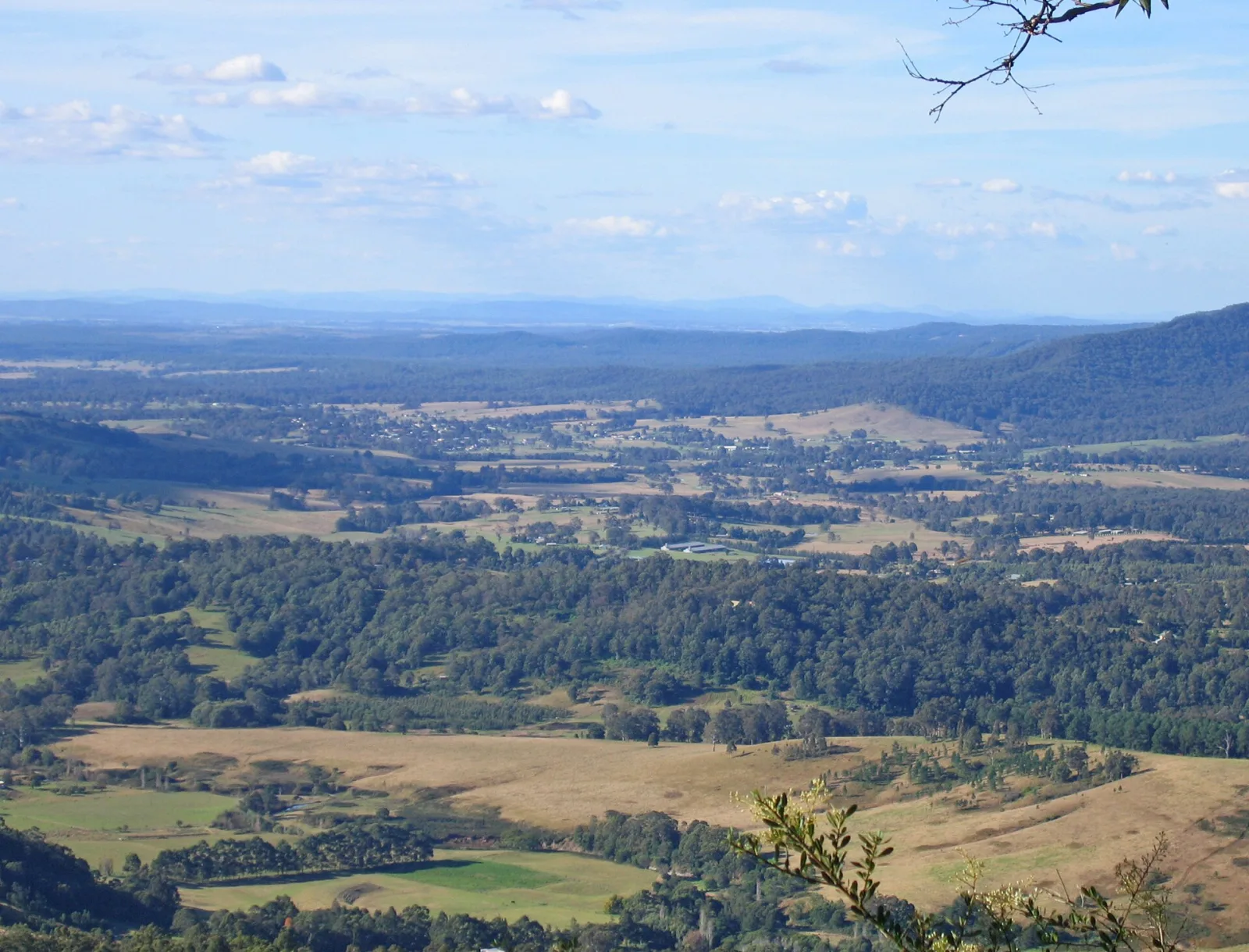
Barrington Tops National Park covers a high basalt plateau on Worimi and Gringai country, sitting between the Hunter Valley wine region and the Manning River. The park was inscribed on the World Heritage list in 1986 as part of the Gondwana Rainforests of Australia, recognising its stands of Antarctic beech forest that have survived here for more than 80 million years since the continent broke away from Gondwana.
The plateau tops out above 1,500 metres and is one of the few places in New South Wales outside the Snowy Mountains that receives regular snowfall in winter. The vegetation changes dramatically with altitude, from warm subtropical rainforest in the lower valleys through cool temperate myrtle beech forest to sub-alpine meadows and snow gum woodland on the ridgeline.
The Antarctic Beech Forest walking track is the most popular short walk, passing through a grove of ancient Nothofagus moorei trees draped in moss and lichen. Longer walks include the Barrington Trail across the plateau and the Rocky River circuit in the lower valleys. The park is also known for its platypus-inhabited rivers and for supporting one of the densest populations of greater gliders in the state.
Access is from Gloucester on the eastern side or Dungog on the southern side, both of which have sealed roads partway into the park before turning to gravel. A 4WD is recommended for the upper plateau tracks, especially after rain.
Common questions
Things visitors ask about Barrington Tops.
Quick answers to help you plan.
How do I get to Barrington Tops from Sydney?
expand_more
The most common route is the M1 Pacific Motorway north from Sydney to Hexham, then the A15 (New England Highway) and B45 to Gloucester, which is the main eastern gateway to the park. Allow around three hours of driving. From Newcastle the same route takes about an hour and a half. From the western side, the plateau is reached from Scone via Thunderbolts Way and Barrington Tops Forest Road.
Is there an entry fee for Barrington Tops National Park?
expand_more
No. There is no vehicle entry or day-use fee for Barrington Tops. Camping fees apply if you stay overnight in one of the NPWS campgrounds. Access is via sealed and unsealed public roads maintained by the surrounding councils.
Do I need a 4WD to visit Barrington Tops?
expand_more
Not for the main access roads. Barrington Tops Forest Road is sealed from Gloucester up to the plateau, then turns to well-maintained gravel that is generally manageable in a 2WD in dry conditions. A high-clearance 4WD is needed for the plateau trails proper (the Barrington Trail, Manning Road, Middle Ridge Road), and for any driving after heavy rain or snow. NPWS closes some tracks seasonally to allow them to recover.
When is the best time of year to visit?
expand_more
October to April gives you the most comfortable weather, with daytime temperatures around 20 degrees on the plateau and the rainforest walks at their greenest. June to August is the cold-and-snow window, when you can occasionally see the plateau under fresh snow but when unsealed roads can become impassable. The shoulder months (September to October, April to May) tend to be the sweet spot for bushwalking.
Can you camp in the park and do I need to book?
expand_more
Yes. Polblue, Devils Hole, Gloucester River, Gummi Falls and Horse Swamp are the main NPWS campgrounds. Polblue is the largest and suits caravans and camper trailers, while Devils Hole sits at around 1,400 metres and is one of the highest campgrounds in Australia. Most Barrington Tops campgrounds are first-come, first-served with self-registration and cash-only fees around $5 to $10 per adult per night, so there is no online booking system and no guaranteed site.
Where is the best short walk for a day visit?
expand_more
The Antarctic Beech Forest walk is the headline short track, a flat, easy loop of around one kilometre through ancient Nothofagus moorei trees draped in moss and lichen. Thunderbolts Lookout on the western side is a quick stop for big views across the plateau, and the Jerusalem Creek walk near Gloucester River campground is an easy valley-floor option with swimming holes.
Does it actually snow at Barrington Tops?
expand_more
Yes, in most winters. The plateau is one of the few places in New South Wales outside the Snowy Mountains that receives regular snowfall, usually between June and early September. Snow is unpredictable and short-lived, and roads up to the plateau can be closed by police during heavy falls. Chains are not typically required but high-clearance vehicles are a good idea if snow is forecast.
Can you see platypus in Barrington Tops?
expand_more
Yes, the park is one of the more reliable platypus-spotting destinations in eastern Australia. The Barrington and Gloucester Rivers, and the creeks around the Gloucester River campground, all support resident populations. Early morning and late afternoon at quiet pools are the best times. Stay on the bank, avoid loud noise, and bring binoculars rather than expecting a close approach.
Where should I stay if I am not camping?
expand_more
Gloucester is the main base on the eastern side of the park, with motels, pubs and farm-stay cabins within easy driving distance of the rainforest trailheads. Dungog, Barrington and the surrounding Hunter Valley towns offer guest houses and luxury retreats. There is no accommodation on the plateau itself outside the campgrounds.
Whose Country is Barrington Tops on?
expand_more
Barrington Tops sits on the traditional Country of the Worimi and Gringai peoples. Both groups have a deep cultural connection to the rivers, rainforest and plateau grasslands, and are acknowledged as Traditional Owners by NPWS. Respect signposted cultural sites and take nothing from the park.
Why is the park World Heritage listed?
expand_more
Barrington Tops was added to the World Heritage list in 1986 as part of the Gondwana Rainforests of Australia. The listing recognises its cool temperate Antarctic beech forests, which descend from plants that have grown continuously on this part of the continent for more than 80 million years, since Australia broke away from the Gondwana supercontinent. The park also protects one of the most biodiverse forests in New South Wales, with more than 50 species of mammals and over 300 bird species recorded.
Scenic views
Lookouts near Barrington Tops.
You may also like

Hunter Valley

Port Stephens

Myall Lakes

Nambucca Heads

Bald Rock National Park
Armidale
Wagga Wagga
Marks Point
Circular Quay

Kiama
Sydney Opera House

King Street Wharf
Attribution
Sources & credits
Content (7)
- Wikipedia: Barrington Tops · CC BY-SA 4.0
- Barrington Tops National Park · NSW National Parks and Wildlife Service
- Polblue campground and picnic area · NSW National Parks and Wildlife Service
- Devils Hole campground · NSW National Parks and Wildlife Service
- Where to find the best 4WD trails in Barrington Tops · Barrington Coast tourism
- Directions to Barrington Tops · Barrington Coast tourism
- Gondwana Rainforests of Australia (World Heritage listing) · UNESCO World Heritage Centre
Images (2)
- Lower Hunter from the Watagans to Mulbring to the 'Tops'.jpg · Tim Keegan · CC BY-SA 2.0
- View into the Hunter Valley - Barrington Tops National Park.... · Schopier · CC BY-SA 4.0
Images sourced from Wikimedia Commons under licenses that permit commercial use. If you are the rights holder and believe an attribution is incorrect, please contact us.